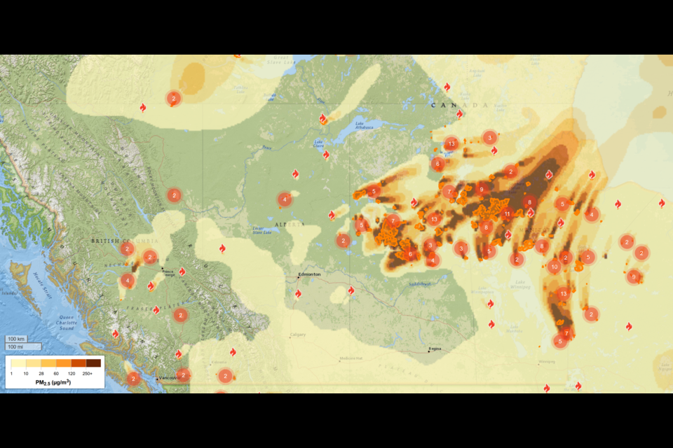
Wildfire smoke from ongoing fires in the Bulkley-Nechako and Cariboo regions has been drifting toward Prince George. Although Environment Canada’s health warnings on Monday and Tuesday were lifted as the city’s air cleared, the risk of smoky conditions remains. Winds may shift and bring smoke back to Prince George residents.
A special air quality statement remains active for Prince George. This warning extends along Highway 16 from Bednesti Lake to Upper Fraser (Willow River) and along Highway 97 from Hixon to the southern edge of McLeod Lake. The smoke is coming mainly from fires in the Bulkley-Nechako zone.
According to the wildfire smoke tracking website firesmoke.ca, mild smoke is expected to return over the next 48 hours. The site forecasts moderate smoke drifting to Prince George from the Bulkley-Nechako fires. One of these fires led to an evacuation order on Monday.
The Dorman Lake fire (G41285), started by lightning on August 1, has grown to 320 hectares. The Regional District of Bulkley-Nechako ordered evacuation for 10 properties in the area. This order covers all land and buildings between Holy Cross Hallet Lake Forest Service Road and Lily Lake Road, south of Smith Creek Road and northwest of the Nechako River.
One BC Wildfire ground crew and two initial attack teams are actively fighting the Dorman Lake fire. They have heavy equipment and helicopters with water buckets supporting them. Smoke from this fire is visible in Vanderhoof, Fraser Lake, and along Highway 16, with some reaching Prince George.
Fire behavior at Dorman Lake is ranked 2 to 3 on a scale of 6, indicating low to moderate surface fire intensity. Another lightning-started fire west of Dorman Lake (G41250) is currently not threatening any properties.
An evacuation alert is also in effect near Trembleur Lake, about 75 kilometers northwest of Fort St. James. This is related to another active fire in that area.
In total, the Prince George fire zone has 13 active wildfires. Three are out of control, five are under control, and five are held by crews. Most fires cover less than one hectare. Weather forecasts predict showers over the next two days, which will help firefighters by reducing fire intensity.
Prince George Fire Centre officer Jeromy Corrigan said the weather is working in their favor. “We expect cloudy skies and some rain in the Vanderhoof area over the next 48 hours. Cooler temperatures and showers will slow fire spread and help crews manage these wildfires.”
As of Tuesday morning, British Columbia had 135 active wildfires, including 16 that started in the previous 24 hours. The Prince George Fire Centre, which covers northeastern BC, has seen 59 new fires since July 31 after a series of lightning strikes.
The Bulkley-Nechako region issued an evacuation alert for the Sam Ross Creek fire, located 33 kilometers southeast of Burns Lake. This alert covers land north and south of Highway 16 between Glenannan Road to the east and the Electoral Area E boundary to the west. It also extends south near Francois Lake, covering all properties west of the Glenannan Road and Francois Lake Road intersection.
Another evacuation alert has been in place since August 1 near Trembleur Lake. This covers the northeastern section of Rubyrock Provincial Park, south of Middle Forest Service Road, within six kilometers of Trembleur Lake’s north shore.
In the Cariboo Fire Centre, the Snaking River fire is the biggest concern. It expanded rapidly from 150 hectares on August 1 to 1,164 hectares within days. An evacuation alert for a 755-hectare area along Harrington Road was extended by the Cariboo Regional District, and the Nazko First Nation also issued an alert.
Fire information officer Amandah Cullum said favorable weather is aiding firefighting efforts. “Cooler temperatures and higher humidity over the last two days helped reduce fire behavior. We mostly see Rank 1 fire activity, with some pockets of Rank 2, so the fire has not grown significantly.”
Seventy-six firefighters, seven heavy equipment units, helicopters, and fixed-wing air tankers are deployed to fight the Snaking River fire.
Cullum explained the main strategy: “Crews are building a fuel-free guard along the northern flank and progressing south along the eastern and western sides. The goal is to prevent the fire spreading southwest and west by connecting control lines to natural barriers like cutblocks and meadows. About half of these objectives are complete.”
Fire crews plan to use a controlled burn to fight the fire. “We have developed a plan for aerial ignition on the southwestern corner of the fire, covering up to 140 hectares,” Cullum said. “This could begin as soon as Tuesday, if weather and site conditions allow.”
The controlled burn aims to remove unburnt fuel between the fire’s edge and control lines. This reduces the risk of the fire growing uncontrollably and helps firefighters manage the blaze more effectively.
Heavy equipment and retardant lines support this operation. Ground crews have set up hoses and water delivery systems ahead of time. Additional personnel, equipment, and helicopters will monitor the fire line to keep the fire within the planned area.

